Maps of the Ottoman Empire

The W. F. Albright Institute of Archaeological Research (AIAR) in Jerusalem in cooperation with the Center for Ancient Middle Eastern Landscapes (CAMEL) at the University of Chicago scanned and geo-referenced a series of topographical maps of Eastern Turkey and the lands of the broader Ottoman Empire with a grant from the US Department of Education TICFIA program. The bulk of the collection contains topographical maps compiled at the British Intelligence Division War Office in 1915 derived from map and survey data collected during multiple expeditions 1839-1906. The collection contains high resolution copies of the original maps held by AIAR, and geo-referenced versions can be requested by contacting dlir@caorc.org.Carte du Liban d'apres les reconaissances de la brigade topographique du Corps Expeditionnaire de Syrie en 1860-61
Description: Map of Lebanon from an expedition of Syria 1860-1861.Publisher: Paris : France. Depot de la GuerreContributor: W. F. Albright Institute of Archaeological Research (AIAR)Collection:Maps of the Ottoman EmpireKarte des Ostjordanlandes : Blatt A1/2
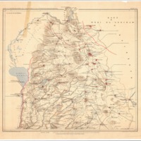
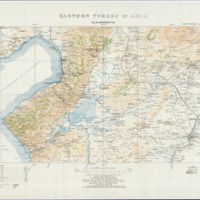
Description: Map of the lands of Jordan (centered on modern day northern Israel). Compiled at the Intelligence Division War Office by Major F.R. Maunsell, R.A. derived from multiple expeditions 1839-1906.Publisher: Leipzig : Deutschen Verein zur Erforschung PalaestinasContributor: W. F. Albright Institute of Archaeological Research (AIAR)Collection:Maps of the Ottoman EmpireEastern Turkey in Asia : Sheet 29 - Meskene
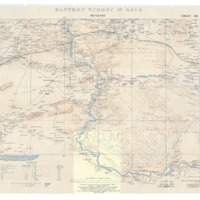
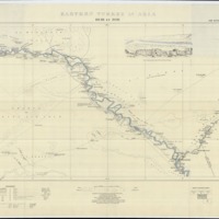
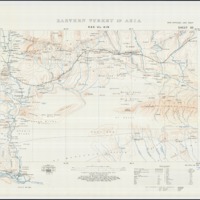
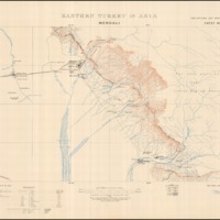
Description: Map of Eastern Turkey (centered on modern day northern Syria showing the Euprates River). Compiled at the Intelligence Division War Office by Major F.R. Maunsell, R.A. derived from multiple expeditions 1839-1906. [Incomplete map with cut section].Publisher: London : British War OfficeContributor: W. F. Albright Institute of Archaeological Research (AIAR)Collection:Maps of the Ottoman EmpireEastern Turkey in Asia : Sheet 25 - Mardin
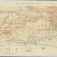
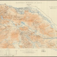
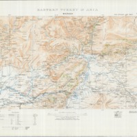
Description: Map of Eastern Turkey. Compiled at the Intelligence Division War Office by Major F.R. Maunsell, R.A. derived from multiple expeditions 1839-1906.Publisher: London : British War OfficeContributor: W. F. Albright Institute of Archaeological Research (AIAR)Collection:Maps of the Ottoman EmpireEastern Turkey in Asia : Sheet 32 - Mosul
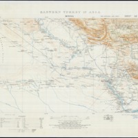
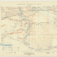
Description: Map of Eastern Turkey (centered on modern day northern Iraq in Mosul area). Compiled at the Intelligence Division War Office by Major F.R. Maunsell, R.A. derived from multiple expeditions 1839-1906.Publisher: London : British War OfficeContributor: W. F. Albright Institute of Archaeological Research (AIAR)Collection:Maps of the Ottoman EmpireEastern Turkey in Asia : Sheet 44 - Deir ez Zor
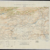
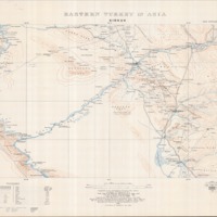
Description: Map of Eastern Turkey (centered on modern day Syria in the Deir ez Zur area). Compiled at the Intelligence Division War Office by Major F.R. Maunsell, R.A. derived from multiple expeditions 1839-1906.Publisher: London : British War OfficeContributor: W. F. Albright Institute of Archaeological Research (AIAR)Collection:Maps of the Ottoman EmpireEastern Turkey in Asia : Sheet 23 - Urfa
Description: Map of Eastern Turkey. Compiled at the Intelligence Division War Office by Major F.R. Maunsell, R.A. derived from multiple expeditions 1839-1906.Publisher: London : British War OfficeContributor: W. F. Albright Institute of Archaeological Research (AIAR)Collection:Maps of the Ottoman EmpireEastern Turkey in Asia : Sheet 27 - Urmia Julamerk
Description: Map of Eastern Turkey. Compiled at the Intelligence Division War Office by Major F.R. Maunsell, R.A. derived from multiple expeditions 1839-1906.Publisher: London : British War OfficeContributor: W. F. Albright Institute of Archaeological Research (AIAR)Collection:Maps of the Ottoman EmpireEastern Turkey in Asia : Sheet 33 - Rowanduz
Description: Map of Eastern Turkey (centered on modern day northern Iraq in Rawaduz area). Compiled at the Intelligence Division War Office by Major F.R. Maunsell, R.A. derived from multiple expeditions 1839-1906.Publisher: London : British War OfficeContributor: W. F. Albright Institute of Archaeological Research (AIAR)Collection:Maps of the Ottoman EmpireEastern Turkey in Asia : Sheet 30 - Ras-Ul-Ain
Description: Map of Eastern Turkey (centered on modern day Syria). Compiled at the Intelligence Division War Office by Major F.R. Maunsell, R.A. derived from multiple expeditions 1839-1906.Publisher: London : British War OfficeContributor: W. F. Albright Institute of Archaeological Research (AIAR)Collection:Maps of the Ottoman Empire
Eastern Turkey in Asia : Sheet 31 - Sinjar
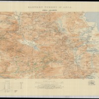
Description: Map of Eastern Turkey (centered on modern day Syria). Compiled at the Intelligence Division War Office by Major F.R. Maunsell, R.A. derived from multiple expeditions 1839-1906.Publisher: London : British War OfficeContributor: W. F. Albright Institute of Archaeological Research (AIAR)Collection:Maps of the Ottoman EmpireEastern Turkey in Asia : Sheet 28 - Alexandretta
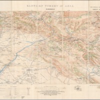
Description: Map of Eastern Turkey (centered on modern day northern Syria in Iskenderun area). Compiled at the Intelligence Division War Office by Major F.R. Maunsell, R.A. derived from multiple expeditions 1839-1906.Publisher: London : British War OfficeContributor: W. F. Albright Institute of Archaeological Research (AIAR)Collection:Maps of the Ottoman EmpireEastern Turkey in Asia : Sheet 13 - Bayazid
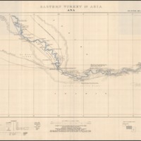
Description: Map of Eastern Turkey. Compiled at the Intelligence Division War Office by Major F.R. Maunsell, R.A. derived from multiple expeditions 1839-1906.Publisher: London : British War OfficeContributor: W. F. Albright Institute of Archaeological Research (AIAR)Collection:Maps of the Ottoman EmpireEastern Turkey in Asia : Sheet 43 - Ana
Description: Map of Eastern Turkey (modern day Iraq and Syria along the Euphrates River). Compiled at the Intelligence Division War Office by Major F.R. Maunsell, R.A. derived from multiple expeditions 1839-1906.Publisher: London : British War OfficeContributor: W. F. Albright Institute of Archaeological Research (AIAR)Collection:Maps of the Ottoman EmpireEastern Turkey in Asia : Sheet 45 - Mendali
Description: Map of Eastern Turkey (modern day Iraq and Iran). Compiled at the Intelligence Division War Office by Major F.R. Maunsell, R.A. derived from multiple expeditions 1839-1906.Publisher: London : British War OfficeContributor: W. F. Albright Institute of Archaeological Research (AIAR)Collection:Maps of the Ottoman EmpireEastern Turkey in Asia : Sheet 22 – Marash
Description: Map of Eastern Turkey. Compiled at the Intelligence Division War Office by Major F.R. Maunsell, R.A. derived from multiple expeditions 1839-1906.Publisher: London : British War OfficeContributor: W. F. Albright Institute of Archaeological Research (AIAR)Collection:Maps of the Ottoman EmpireEastern Turkey in Asia : Sheet 29 - Meskene
Description: Map of Eastern Turkey (centered on modern day northern Syria showing the Euprates River). Compiled at the Intelligence Division War Office by Major F.R. Maunsell, R.A. derived from multiple expeditions 1839-1906.Publisher: London : British War OfficeContributor: W. F. Albright Institute of Archaeological Research (AIAR)Collection:Maps of the Ottoman EmpireEastern Turkey in Asia : Sheet 35 - Kirkuk
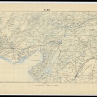
Description: Map of Eastern Turkey (centered on modern day Iraq in Kirkuk area). Compiled at the Intelligence Division War Office by Major F.R. Maunsell, R.A. derived from multiple expeditions 1839-1906.Publisher: London : British War OfficeContributor: W. F. Albright Institute of Archaeological Research (AIAR)Collection:Maps of the Ottoman EmpireAlep
Description: Map of Southern Turkey.Publisher: Bureau Topographique de A.F.L.Contributor: W. F. Albright Institute of Archaeological Research (AIAR)Collection:Maps of the Ottoman Empire
And see AWOL's Roundup of Resources on Ancient Geography


