[Most recently updated 22 October 2018]Included in the following list are links to digital project dealing with geography and the ancient world. It is an eclectic list, culled mostly from entries in AWOL. It has no pretentions of being complete or comprehensive, but is offered to give readers a sense of the range of materials currently accessible. I have (for the most part) not included the scores of atlases, maps and other orginally paper-based geographical resources which are accessible online in facsimile.
I welcome comments, suggestions for sites to include, notices of projects under development, and any other sorts of reactions you may have. Please use the comment function below, or email me directly. I'm easy to find.
2300 Ancient Sites on Google Earth On several occasions I have blogged on the possibilities of Google Earth and its online spin-off, Google Maps. My last blog on this topic was a bit over half a year ago, when I had some 1700 items available. In the meantime, I have added more than 550 ancient sites to my list, from all quarters of the ancient world.
AdriAtlas: Atlas informatisé de l'Adriatique antique (1100 a.C. - 751 p.C.)Cet Atlas, lié à une base de données constamment enrichie, a pour but de fournir un état de la recherche sur l'Adriatique antique entre le XIe s. av. J.-C. et le milieu du VIIIe s. ap. J.-C. C'est une réalisation du programme international AdriAtlas financé par l'Agence Nationale de la Recherche (partenaires : Ausonius-Bordeaux, Ecole française de Rome, M²ISA-Paris), la Région Aquitaine et l'Ecole française de Rome. Jusqu'à présent, seule l'Adriatique orientale a été couverte, avec la collaboration des Instituts d'archéologie de Ljubljana (Slovénie) et de Tirana (Albanie), les Universités de Trieste (Italie), Pula, Zadar et Zagreb (Croatie), de l'université catholique de Croatie et des chercheurs des universités de Bordeaux, Clermont-Ferrand et Grenoble. Actuellement les sites de l’Adriatique occidentale connus par les sources écrites sont progressivement ajoutés par les équipes universitaires de Bari, Bologne, Chieti, Ferrare, Foggia, Lecce, Macerata, Padoue, Trieste et Vérone.
Amphores. Recueil de timbres sur amphores romaines (RATAR)Depuis quelques décennies, les amphores ont pris la première place comme source de l'étude des échanges dans l'Antiquité. Les inscriptions qu'elles portent fondent la connaissance de l'organisation de leur production, de leurs contenus et de leur distribution. Depuis de nombreuses années, une petite équipe du Centre Camille Jullian, Université de Provence – CNRS, étudie les timbres sur amphores romaines et a constitué une base de données, informatisée depuis 1987, à partir de publications. Le lecteur peut se reporter aux introductions des deux volumes RTAR I et II cités ci-dessous où les principes suivis pour la constitution de la base de données sont exposés.
Anatolian AtlasThe Anatolian Atlas is a resource for scholars interested in the archaeological settlement patterning and historical geography of Ancient Anatolia (modern day Turkey).
Here you will find Google Maps that display the extents of various archaeological surveys that have been conducted in Anatolia as well as numerous archaeological sites. These sites, when possible, are linked to online content that provides more information. They also often have citations for scholarly work that has discussed them. The works that are cited can be found in the bibliography.
Finally, the Anatolian Atlas also hosts original research that has been developed in CAMEL by scholars of the Oriental Institute.
The Anatolian Roads ProjectThis site is dedicated to research in the field of the Roman road system located in ancient Anatolia, present-day Turkey. The site is sponsored by the History department of Wisconsin Lutheran College under the direction of Dr. Glen L. Thompson and by the Asia Minor Research Center under the direction of Dr. Mark Wilson. The Anatolian Roads Project (TARP) is a work in progress and thus will be updated and improved as time goes on.
Ancient Mediterranean PortsThe Union of Ancient Mediterranean Ports was created in 1995 from a network of cities with the common characteristic of having been founded during Greek antiquity. The union was enacted in 1996 with its headquarters in the ancient town of Agatha, current Aged of Southern France...
Ancient Locations:Database of Archaeological SitesANCIENT LOCATIONS is my collection of Placemarks of archaeologically interesting locations of the ancient world.
The list is continuously updated and expanded to give anyone with an interest in archaeology and history the possibility to look up the coordinates of relevant sites.
Locations are included if they existed prior to 476 CE in the Old World (end of the West-Roman Empire) and prior to 1492 CE in the New World (re-discovery of the New World).
Ancient Ports – Ports AntiquesLe Projet d’inventaire des Ports Antiques
This web site presents work done to collect, identify and locate ancient harbours and ports. It is based on a study of existing documentation and does not aim at finding new ports that were unknown at the time of writing. The result is a list of around 2750 ancient ports based on 66 ancient authors and a few modern authors.
Ancient World Mapping CenterRecently the Center has been able to acquire its own server, so this is the ideal opportunity to revise and upgrade the website now launched here. The new site provides a robust platform to host the Center’s activities, especially its online initiatives Antiquity À-la-carte and the newly conceived Benthos project. Please explore and enjoy. You are encouraged to join the AWMC community and participate by registering yourself as a user of the site. The Center can only function with much valued support from donors. If you too would like to make a contribution, please visit the Support AWMC page.
ANE Placemarks for Google EarthFrom Olof Pedersén
A preliminary set of placemarks (ANE.kmz) for Google Earth of a selection of the most important archaeological sites in the Ancient Near East can be downloaded here (as an alternative try right-click or ctrl-click).
Antiquity À-la-carteThe Antiquity À-la-carte application is an interactive digital map of the ancient world.
APAAME: Aerial Photography Archive for Archaeology in the Middle EastAPAAME is long-term research project directed by Professor David Kennedy and Dr Robert Bewley, and is based at the University of Western Australia. The project is designed both to develop a methodology suited to the region and to illuminate settlement history in the Near East. The archive currently consists of almost 45,000 aerial images, over 40,000 of which are displayed on the archive’s Flickr site.
Although principally focused on Jordan, in which there has been an annual programme of flying since 1997 (The Aerial Archaeology in Jordan Project), high resolution satellite imagery on Google Earth is now permitting research on neighbouring countries.
We will be keeping you up to date on what we are finding, how we are finding it, and also taking you with us on our fieldwork in Jordan.
ArchéoGéographieLe site de l'archéogéographie est une réalisation du Groupe de Recherches du CNRS intitulé "Traité de l'ESpace des Sociétés Rurales Anciennes" (= GDR 2137, TESORA). Ce groupe, dont l'existence institutionnelle prend fin en 2007 après 8 années d'existence, a conçu et formalisé une discipline nouvelle nommée archéogéographie et rédigé le Traité d'archéogéographie qui lui sert de base (en cours de parution).
L'archéogéographie est enseignée à l'Université de Paris-I Sorbonne dans le cadre d'un Master “archéologie et environnement”, dont elle constitue une des quatre options. Les cours d'archéogéographie sont donnés par Gérard Chouquer, Magali Wateaux, Sandrine Robert. La direction de thèses sur des thèmes d'archéogéographie est assurée par Gérard Chouquer dans le cadre d'un Doctorat d'archéologie de l’École Doctorale d’Archéologie de l’Université de Paris I (ED 112). Certaines thèses sont encadrées en co-direction avec Joëlle Burnouf.
À partir de l'année universitaire 2007-2008, l'archéogéographie est enseignée à Coimbra, dans le cadre d'un Master "Archéologie et territoires", Spécialisation Archéogéographie, et, à partir de 2008/2009 dans le cadre d'un Doctorat d'archéogéographie. L'encadrement des thèses du doctorat d'archéogéographie sera assurée par Maria da Conceição Lopes.
Le responsable du site internet de l'archéogéographie est Gérard Chouquer, directeur de recherches au CNRS dans l'équipe Arscan ("Archéologie et Sciences de l'Antiquité" UMR 7041 du CNRS) et la sous-équipe "Archéologies environnementales" que dirige Joëlle Burnouf.
Archaeological Survey of Israel -
English -
HebrewThe sites documented in the Archaeological Survey of Israel are published on the website where they are displayed in survey squares of 100 sq km (10 × 10 km). The list of maps is presented below in alphabetic order, according to their names and numbers as recorded in Yalquṭ Ha-Pirsumim. The survey maps can be seen on the right side of the screen against the background of an aerial photograph. The sites (marked with yellow dots) can be accessed by zooming in on the screen and a description of them will appear by clicking on the dots. The introduction to each map and search options are also displayed.
ArchAtlas
ArchAtlas is a web-orientated archaeological mapping and research project, founded by the late Prof. Andrew Sherratt, which continues to be developed at the Department of Archaeology, University of Sheffield, UK.
Археологическая карта Крыма Археологические экспедиции, регулярно работающие в Крыму.
История Крыма открывается нам во многом благодаря археологическим раскопкам. В приводимом ниже списке и на карте указаны экспедиции, в течение многих лет проводящие археологические исследования в Крыму на ряде крупных памятников. В некоторые из экспедиций можно поехать волонтером. Волонтерам, как правило, приходится оплачивать свое пребывание. Более подробную информацию Вы можете найти на сайтах экспедиций, если таковые есть и функционируют, либо, установив контакты с прошлыми участниками или руководством. Многие, побывавшие в экспедициях, и дальше именно так предпочитают проводить отдых в Крыму и история Крыма, открываемая археологией, становится частью их жизни. Подчеркну, что экспедиций, конечно, гораздо больше, но многие носят кратковременный характер, и часто их задачей являются раскопки отдельного объекта. В этом случае, как правило, экспедиции немногочисленны, раскопки выполняются профессиональными археологами с привлечение небольшого числа опытных рабочих.
Welcome to Mapping Mesopotamian Monuments.
Mapping Mesopotamian Monuments presents a topographical survey of the standing historical and architectural remains in the region from Kurdistan to southern Iraq. A work in progress, this monument survey covers all historical periods from ancient to modern. It includes ancient Mesopotamian rock reliefs carved into the cliff faces of the mountains, early Christian churches and monasteries, early Islamic, Ottoman and twentieth century architecture. The database of images invites you to explore the multiple layers of the rich historical landscape of Mesopotamia. Envisioned and directed by Professor Zainab Bahrani, the basis of the survey is a field project that assesses the condition of monuments, maps their locations, and records them with digital techniques to provide a record and to facilitate future preservation and conservation work across this land. In the first season (2013) the team documented the major monuments and historical architecture of the Dohuk region and the city of Erbil, one of the oldest continuously inhabited sites in the world.
ARMEP: Ancient Records of Middle Eastern PolitiesARMEP 1.0’s interactive map interface displays the find spots of about 6,700 ancient texts, all of which were written in the Akkadian and Sumerian languages and in cuneiform script. Most of these inscribed artifacts were discovered in modern-day Iraq, Syria, and Turkey, while others originate from Egypt, Iran, Lebanon, and Saudi Arabia. Although the texts range in date from ca. 2334 to 64 BC, most come from Neo-Assyrian times (744-612 BC). The dataset is derived from the Open Richly Annotated Cuneiform Corpus (Oracc) and it includes texts from the following projects: Inscriptions of Suhu online (Suhu; LMU Munich); Royal Inscriptions of Assyria online (RIAo; LMU Munich); Royal Inscriptions of Babylonia online (RIBo; LMU Munich) Royal Inscriptions of the Neo-Assyrian Period (RINAP; UPenn and LMU Munich); and State Archives of Assyria online (SAA; formerly UCL, now LMU Munich).
Assyrian empire builders links to a set of useful
External Resources. Among these is:
Explore the locations of Assyrian cities using our content for Google Earth. Download all Google Earth content (KMZ files) used in People, Gods & Places (12KB). Follow these instructions to download Google Earth for your computer.
Atlas archéologique de la TunisieBabelon, Ernest. Atlas archéologique de la Tunisie : édition spéciale des cartes topographiques publiées par le M inistère de la Guerre. accompagnée d'un texte explicatif rédigé par Mm. E. Babelon, R. Cagnat, S. Reinach. [Texte] / . Paris 1893.
Atlas archéologique de l'AlgérieGsell, Stéphane. 1864-1932: Atlas archéologique de l'Algérie : édition spéciale des cartes au 200.000e du Service Géographique de l'Armée / avec un texte explicatif rédigé par Stéphane Gsell. Texte. . Alger : Paris 1911.
Atlas des Sites du PRoche-Orient (ASPRO)L’ Atlas des Sites du Proche-Orient (ASPRO) se présente comme un répertoire analytique de près de 2 000 sites occupés entre 14 000 et 5 700 BP (environ 14 000 - 4 500 av. J.-C.) sur un territoire qui s’étend du Sinaï au Turkménistan et de l’Anatolie au golfe Arabo-Persique.
Atlas of Old Iranian InscriptionsAtlas: Middle East & North Africa
![http://www.ecoi.net/atlas_mena.pdf]()
Atlas PALM: Atlas du Patrimoine Archéologique Littorale MéditerranéenLe projet

Né de la volonté de mettre à disposition de tous une part méconnue du patrimoine culturel, l’Atlas PALM propose de mettre en ligne et en lumière 60 années de découvertes et de recherches archéologiques sous-marines sur les côtes de la région Provence-Alpes-Côte d'Azur.
Si la pratique de l'archéologie sous-marine est relativement récente, l'exploration des fonds méditerranéens français a néanmoins généré au cours des soixante dernières années une documentation riche, abondante et variée. La diversité de ce patrimoine archéologique illustre, sur plusieurs millénaires, l'histoire des régions littorales françaises et leur rôle d'interface entre monde méditerranéen et continent européen. A l'inverse du patrimoine terrestre, ces vestiges, pourtant témoins et acteurs de l'identité méditerranéenne, sont souvent invisibles ou inaccessibles, immergés, fragiles, en proie aux pillages et aux destructions.
Atlas Préhistorique de la Tunisie at the Institut National du Patrimoine, Tunisie
Two additional fascicles are available at the digital library of theÉcole Française de Rome
Atlas préhistorique de la Tunisie. 1. Tabarka. 1985.
Atlas préhistorique de la Tunisie. 2. Bizerte. 1985.
The Archaeological Sites of the Aegean MinoansThe Aegean Minoan 3D GIS Project was initiated in 2007 to produce a three-dimensional (3D) full-color mapping of the archaeological sites of the Minoans in the Aegean Sea area using Google Earth. It is intended to be a definitive geographical reference available to everyone. While this is an ongoing project and we are always looking to improve it, thanks to the many contributing scholars and volunteers it is by far the most comprehensive and accurate mapping of its kind ever made and includes the sites and geographical features listed below.
Benthos: Digital Atlas of Ancient Waters beta versionBenthos is a new initiative of the Ancient World Mapping Center that aims to catalog and map the waters of the ancient Mediterranean basin, including both physical and cultural geography. The project will provide interactive maps of Mediterranean shipping networks, bathymetric data, and views of ancient coastlines. Currently the project is in a preliminary state, with a functional beta version of the application based off of Antiquity À-la-carte.
Click here ... in order to launch the map application. This application works best with Firefox, Chrome, or Safari and currently does not work correctly with Internet Explorer.
Bible Geocoding: The location of every identifiable place mentioned in the Bible The Big Ancient MediterraneanBAM was developed at the University of Iowa by Paul Dilley (University of Iowa), Sarah E. Bond (University of Iowa), and Ryan Horne (UNC-Chapel Hill). The open-access project integrates GIS tools, network analysis, and textual annotation/data mining capabilities in order to allow the exploration and visualization of ancient texts in new ways. The first individual module within Big Ancient Mediterranean is called Terra Biblica. Terra Biblica is a tool for the geospatial analysis, literary network visualization, and plot mapping of biblical and related texts up to the year 337 CE. BAM also houses the Iowa Canon of Latin Authors. The Iowa Canon of Latin Authors and Works is a catalogue and information repository for all extant Latin authors and their writings, including fragmentary texts, as well as translations into Latin, from the earliest period through the seventh century CE.
British Library Maps at Pelagios CommonsDuring Phase 3 of Pelagios (2014/2015) we worked with various sources to encompass “Early Geospatial Documents” – including early Christian Mappae Mundi and pilgrimages, Portolan charts, and Islamic and Chinese maps. In collaboration with the team at the British Library, and funded by the A W Mellon Foundation, the following digital sources are available to download and use. Each is accompanied by an XML and Excel file containing catalogue information relating to each image.
Carta Archeologica di RomaOn-line la Carta Archeologica di Roma
E' consultabile sulla piattaforma web il lavoro preparatorio della Carta Archeologica di Roma, conservato nel patrimonio documentario dell'Archivio Storico a Palazzo Altemps, edito sotto forma di ebook a cura di Luigia Attilia.
La carte nationale des sites archéologiques et des monuments historiques : feuilles 1/50 000Responsable Scientifique et Administratif : Mustapha KHANOUSSI
Responsable NTIC : Ali DABBAGHI
1. Nature: Projet présidentiel
2. Références
- décision du Conseil Ministériel Restreint sous la présidence de son Excellence le Président de la République du 21 Juillet 1991.
- décret n°1443-1992 du 03 août 1992
. Cadre général
Malgré la diversité des projets d'inventaire dès la fin du XIX ème siècle, il n'y a pas encore un inventaire général et exhaustif des sites archéologiques, des monuments historiques et du patrimoine vernaculaire.
4. Contenu
La carte nationale des sites archéologiques et des monuments historiques a vu ses objectifs clairement précisés par le décret n°1443-1992 daté du 3 août 1992 :
Article premier.– Il est institué une carte nationale des sites archéologiques et des monuments historiques en terre et en mer dans le but d’établir l’inventaire général des lieux et édifices qui constituent une partie du patrimoine culturel national.
Article 2.– Pour le recensement des sites et des monuments, il sera procédé à l’établissement et à l’impression des documents suivants :
- carte au 1/50 000e comportant la localisation des sites
- plan au 1/2000 comportant la localisation des monuments et des tissus urbains traditionnels.
- fichier comportant une description des sites et des monuments, une évaluation des superficies, une couverture photographique et, dans la mesure du possible, une enquête foncière préliminaire. »
CHARDA-XploreWe are happy about your interest at CHARDA-Xplore. In the following you will get some short information about the project.
The Chinese Archaeology Database (CHARDA-Xplore) began as part of the research project 'Chinese Metal' (CHIME), located in the research-cluster 2 of the DAI, and was originally designed to collect and document the available information on early Chinese metal finds.
CHARDA-Xplore basically serves as a collection of standardized and geo-referenced archaeological information, providing the possibility to analyze these data statistically and to map spatial and temporal distribution patterns.
China Historical GIS The China Historical Geographic Information System, CHGIS, project was launched in January 2001 to establish a database of populated places and historical administrative units for the period of Chinese history between 221 BCE and 1911 CE. CHGIS provides a base GIS platform for researchers to use in spatial analysis, temporal statistical modeling, and representation of selected historical units as digital maps.
Corinth Computer ProjectA Collaboration Between
University of Arizona& University of Pennsylvania Museum of Archaeology and Anthropology under the auspices of Corinth Excavations, American School of Classical Studies at Athens
Since 1988 a research team from the Mediterranean Section of the University of Pennsylvania Museum of Archaeology and Anthropology at the University of Pennsylvania has been involved in making a computerized architectural and topographical survey of the Roman colony of Corinth. Known as the Corinth Computer Project, the fieldwork has been carried out under the auspices of the Corinth Excavations of the American School of Classical Studies at Athens, Dr. Charles K. Williams II, Director.
CORONA is the codename for the United States’ first photographic spy satellite mission, in operation from 1960-1972. During that time, CORONA satellites took high-resolution images of most of the earth’s surface, with particular emphasis on Soviet bloc countries and other political hotspots in order to monitor military sites and produce maps for the Department of Defense. The more than 800,000 images collected by the CORONA missions remained classified until 1995 when an executive order by President Bill Clinton made them publicly available through the US Geological Survey. Because CORONA images preserve a high-resolution picture of the world as it existed in the 1960s, they constitute a unique resource for researchers and scientists studying environmental change, agriculture, geomorphology, archaeology and other fields.
Database of Roman TemplesThe Rome Research Group is a collection of projects involved in exploring various features of the city of Rome and the world it influenced. Working broadly in the world of the Digital Humanities, current projects are mapping the street shrines (edicole sacre) of Rome, built beginning in the Medieval period, and the temples of the ancient Roman world. Find out more about us here.
Descriptio RomaeL'immagine che gli studiosi hanno di Roma è quella del luogo, per eccellenza, depositario di valori artistico-architettonici di primaria importanza, meta di ogni viaggio (reale o intellettuale) che a quei valori voglia attingere. Paradossalmente la conoscenza della città è resa problematica proprio in ragione della straordinaria estensione del suo patrimonio e della altrettanto vasta - e non coordinata - diffusione delle relative fonti documentarie.
Digital Atlas of Roman and Medieval Civilization (DARMC)
The Digital Atlas of Roman and Medieval Civilization(DARMC) makes freely available on the internet the best available materials for a Geographic Information Systems (GIS) approach to mapping and spatial analysis of the Roman and medieval worlds. DARMC allows innovative spatial and temporal analyses of all aspects of the civilizations of western Eurasia in the first 1500 years of our era, as well as the generation of original maps illustrating differing aspects of ancient and medieval civilization. A work in progress with no claim to definitiveness, it has been built in less than three years by a dedicated team of Harvard undergraduates, graduate students, research scholars and one professor, with some valuable contributions from younger and more senior scholars at other institutions. For more details on who we are, please see the People page...
Digital Atlas of the Roman EmpireJohan Åhlfeldt, Lund, Sweden.
The Digital Archaeological Atlas of the Holy LandThe Digital Archaeological Atlas of the Holy Land (DAAHL) is an international project that brings together experts in information technology including Geographic Information Systems (GIS) and the archaeology of the Holy Land (modern Israel, Palestine, Jordan, southern Lebanon, Syria and the Sinai Peninsula) to create the first on-line digital atlas of the region held sacred to the three great monotheistic faiths - Judaism, Christianity and Islam. Using the power of spatial information systems such as Google Maps and Google Earth, GIS, the tens of thousands of recorded archaeological sites for the region - from the remote prehistoric periods to the early 20th century - will be entered into a comprehensive database along with site maps, photographs and artifacts. The historical and archaeological content for this project will be developed by a team of over 30 international scholars working in the region, helping to provide the data used to create the Atlas. This website and its content will serve as the prototype "knowledge node" of a more comprehensive Digital Archaeological Atlas Network for the Mediterranean region.
Digital Augustan Rome
Digital Augustan Rome is a long term mapping project that is prepared to provide a worthy digital successor to the published book and maps of Mapping Augustan Rome that appeared as Supplement 50 in the Journal of Roman Archaeology Series, 2002. The volume was directed by Lothar Haselberger in collaboration with David Gilman Romano and edited by Elisha Dumser. The entries were written by over 12 authors.
The Digital Gazetteer of the Song DynastyA digital history project at the University of California, Merced
In 1958, Sinologist Hope Wright published a work entitled An Alphabetical List of Geographical Names in Sung China. Originally published in Paris by the Centre de Recherches Historiques of the École Pratique des Hautes Études, and reprinted as a second-generation photocopy in 1992 by the Journal of Song-Yuan Studies, the Alphabetical List is now out of print.
Wright’s compilation is the most comprehensive print source for Song geography in any language. The Digital Gazetteer of Song Dynasty China (DGSD) is a MySQL database derived primarily from the Alphabetical List.
The project is described in this article. The digital map has been created by Johan Åhlfeldt with support from the Pelagios project.
Digitale Topographie der Stadt RomChrystina Häuber
Die Klassische Archäologin Dr. Chrystina Häuber (jetzt Ludwig-Maximilians-Universität [LMU] München, Department für Geographie) und der Geograph und Programmierer Dr. Franz Xaver Schütz (Hochschule München, Fakultät für Geoinformation und FORTVNA Research Center for Archaeological Information Systems Regensburg) haben die Forschungsprojekte "FORTVNA" (1994-2001) und "The Eastern Part of the Mons Oppius in Rome" (2001-2003) gemeinsam durchgeführt. Im Forschungsprojekt "FORTVNA" haben sie das gleichnamige objektorientierte Informationssystem zur Erforschung der Topographie des antiken Rom entwickelt, während das Forschungsprojekt "The Eastern Part of the Mons Oppius in Rome" nach dem Untersuchungsgebiet auf dem Esquilin in Rom benannt war, an dem sie das Informationssystem "FORTVNA" erprobt haben. Um die erzielten Resultate in Karten umzusetzen, begannen sie 2003 mit dem laufenden Forschungsprojekt "AIS ROMA"...
Egyptian Antiquities Information System Newsletter
Egyptian Antiquities Information System is the official Geographic Information System (GIS) department of the Supreme Council of Antiquities (SCA), the government institution responsible for protecting Egyptian archaeological sites. EAIS collaborates with a large number of national and international stakeholders to develop Cultural Resource Management in Egypt and facilitate site management and protection.
EurAtlas: History and Geography of EuropeEuratlas is a website dedicated mainly to the historical geography of Europe but it offers also a world atlas and a wide collection of pictures in order to give a comprehensive view of history and geography.
Our continent is presented here as a wide cultural area limited north by degree 60, east by the Ural - Caspian - Zagros line, south by the Sahara and west by the Atlantic Ocean...
FastiOnline: A database of archaeological excavations since the year 2000Between 1946 and 1987 the International Association for Classical Archaeology (AIAC) published the Fasti Archaeologici. It contained very useful summary notices of excavations throughout the area of the Roman Empire. However, spiraling costs and publication delays combined to render it less and less useful. AIACs board of directors thus decided in 1998 to discontinue the publication and to seek a new way of recording and diffusing new results. The Fasti Online is the result of this effort.
GapVisBETAOverview
GapVis is an interface for exploring and reading texts that reference ancient places. It includes maps and data visualizations that show what locations are referred to a different points in the narrative and allows you to dig into the details to learn more.
GeodiaGeoDia (jee-oh-DEE-uh, short for "geodiachronicity") is intended to provide a simple, intuitive way for people to visualize the temporal, geographic, and material aspects of ancient Mediterranean civilizations. Enter GeoDia >>
GIS Center NewsletterEgyptian Minister of State for Antiquities (MSA), Geographic Information System Center
The GIS Center was founded to improve SCA's ability to protect and manage archaeological sites. This goal was achieved by creating a system for identification of the location and characteristics of archaeological sites and to record them in a searchable GIS and database. The information is then transferred to targeted stakeholders, which enables them to take the existence and significance of these sites into consideration in all conservation, land management and planning, and related socio-economic activities...
GIS in Archaeology: The Complete GuideIntroduction to Geographic Information Systems
Geographic Information Systems (GIS) are tools for the input, analysis and output of spatial data. Geographers initially used these tools for resource management purposes (Burrough 1986). Over the last decade, GIS applications have revolutionized many disciplines in many ways (Marble, 1990), though some disciplines adopted them earlier than others. In the field of archeology, GIS has barely reached the end of the experimental stage. Although it was used fairly regularly in the early 1980?s, (Kvamme, 1996) its present utilization has dramatically increased. At the time this paper was written, over 500 archaeologists worldwide were registered GIS users with the online database "GIS-using archaeologists", developed byPaul Miller and Ian Johnson in 1995. It is suspected that the actual number of GIS users in the archaeology circle is substantially higher.
GlobalXplorer°GlobalXplorer° is an online platform that uses the power of the crowd to analyze the incredible wealth of satellite images currently available to archaeologists. Launched by 2016 TED Prize winner and National Geographic Fellow, Dr. Sarah Parcak, as her “wish for the world,” GlobalXplorer° aims to bring the wonder of archaeological discovery to all, and to help us better understand our connection to the past. So far, Dr. Parcak’s techniques have helped locate 17 potential pyramids, in addition to 3,100 potential forgotten settlements and 1,000 potential lost tombs in Egypt — and she's also made significant discoveries in the Viking world and Roman Empire. With the help of citizen scientists across the globe, she hopes to uncover much, much more. This is just the beginning. With additional funding, Dr. Parcak aims to revolutionize how modern archaeology is done altogether, by creating a global network of citizen explorers, opening field schools to guide archaeological preservation on the ground, developing an archaeological institute, and even launching a satellite designed with archaeology in mind.
Google Ancient PlacesThe Web is seeing an explosion of digitized material being made freely and openly available online. Google Books alone has some 12 million books in over 300 languages; but other collections, such as the Open Library and the Hathi Trust, are also making accessible texts, many of which were previously available only in prestigious university libraries. But the challenge is: What’s there? And how can it be used?
With funding from Google’s Digital Humanities Research Awards, the Google Ancient Places (GAP) project addresses these two primary concerns of discovery and usability using ancient world places as the target information that we want to able to find and visualize. We call this automated process the ‘there and back again’ principle: it’s not enough to empower users to discover ancient places in large text corpora; we also allow users to move back again to find the books that refer to them.
Heritage Gazetteer of CyprusWelcome to the Heritage Gazetteer for Cyprus (HGC). Cyprus has played an important role in the history of many cultures. It has been described in many languages and several different alphabets, over several millennia. This can make identification of places difficult; and it means that interesting historical information may be dispersed, and hard to access.
The overall aim of this project, therefore, is to facilitate the use of a wide range of expertise in recording the historic geography of Cyprus; the resource has been designed to record all locations/monuments attested as in use in any period up to 1882, and all names used for these locations on the island, in any language or period up to the establishment of standard reference systems. Modern administrative districts are named according to the Οδηγός Τυποποίησης Ονομάτων (Nicosia, 2007, available online). Modern toponyms are given in the form used in the Complete Gazetteer of Cyprus (Nicosia, 1987, pp 1-1301 available online: see also the list of Towns and Villages of Cyprus, pp. 1303-1669).
Heritage Gazetteer of LibyaThe Heritage Gazetteer of Libya is designed to provide a tool for exploring the rich historic heritage of Libya, based on the work of members of the Society for Libyan Studies. The core data are drawn from the publications of the Society, including two guidebooks to Tripolitania (2009) and Cyrenaica (2013) by Philip Kenrick; further information is being added from the Archives of the Society, and from other publications by members.
HestiaHestia uses a range of digital technologies as part of a blended, innovative approach to studying the geography of Herodotus’s Histories. Using a freely available digital text of Herodotus from the Perseus on-line library, Hestia captures all place-names mentioned in the narrative, organises that information in a database, and then explores those spatial relations through a series of mapping applications, such as GIS, GoogleEarth and the Narrative TimeMap. Our work both challenges the usual division between East and West by bringing to light the deep network culture that underpins the Histories, and finds ways of bringing Herodotus's world into people's homes.
Hierokles: SynekdemosRyan Horne
Application Information
Early in the reign of Justinian, an otherwise unidentified author named Hierokles composed the Synekdemos, a sprawling list of the provinces and major cities of the Eastern Roman Empire. Containing nearly a thousand toponyms, the Synekdemos is an unparalleled source on the geography of the Byzantine world. It not only indicates the administrative divisions of Justinian’s time, but also suggests what places, in the view of one educated Roman, “mattered” in the early 6th century CE.
Hittite Historical AtlasSince 1906, the excavations at the Hittite capital Boğazköy/Hattusa have yielded thousands of cuneiform tablets and fragments, most of which was published. Nevertheless, there are centres other than Hattusa, which produced tablets. These include Maşat Höyük/Tapigga Kuşaklı/Sarisa Ortaköy/Sapinuwa, Oymaağaç/Nerik and Kayalıpınar/Samuha. The texts from the Hittite centres mention over 4000 geographical names (regions, mountains, rivers, cities), which suggest that the Hittites had a considerable knowledge of their surroundings and geographical terms.
Hittite MonumentsHittite Monuments is an experimental site, built with an aim to provide visual references to all major Hittite monuments. The locations listed below are the sites that has monuments belonging to the times of Hittite/Luwian civilization and culture. The text list below divides the sites in two chronological groups. This is definetely not a complete list, nor the listed sites may have complete information. Some pages are still missing information or images. As time permits I continue to update the pages with more information. I would appreciate any comments, feedback, and information. -Tayfun Bilgin
Holy Land Maps from the Eran Laor Cartographic CollectionThe Holy Land has been the subject of a relatively large number of maps, chiefly due to its religious importance. Some of the earliest maps reflected ancient traditions of mapping such as that of Ptolemy; others were meant to illustrate the Holy Scriptures. Some maps were printed separately; while others were published as part of atlases, itineraries and travel books. Owners who could afford the expense added coloring to their maps.
Arama kutusundan güncel yer adı (ör: Killik), eski yer adı (ör: Sıddıkiye), veya il/ilçe (ör: Gürpınar) adıyla arama yapabilir veya sağdaki haritaya tıklayarak yer adı bulabilirsiniz.
Üye olmak koşuluyla düzeltme yapabilir ve yeni bilgi ekleyebilirsiniz. Üye olmak için geçerli bir e-mail adresi ile kullanıcı adı almanız yeterlidir.
Projenin amacı TC sınırları içerisinde halen var olan ve geçmişte kullanılmış tüm yer adlarını belgelemektir. Halen veritabanında 42154 güncel kayıt, 33624 eski yer adı mevcuttur. Kullanıcıların katkısıyla bu sayıların artacağını umuyoruz.
The Interactive Nolli MapThe Nolli Web Site presents the 1748 Nolli map of Rome as a dynamic, interactive, hands-on tool. The public now has access to cataloged information about the map in both written and graphical form. The map not only provides rich information, but it has the ability to be updated with new data over time to embrace expanding knowledge.
iDAI.gazetteer Der iDAI.gazetteer ist ein Werkzeug, um die Ortsdaten-Struktur innerhalb des DAI sukzessive zu optimieren, d. h. sowohl die Zahl der mit Ortsdaten versehenen Informationsobjekte zu erhöhen, diese dann in die weltweiten Ortsdatensysteme einzubinden, und auch die im DAI schon vorhandenen Informationsobjekte mit Ortsdaten zu vereinheitlichen. Der iDAI.gazetteer ist somit der Auftakt zu einem großen, neuen Querschnitts-Arbeitsfeld.
IrancartoIrancarto est un site de recherche consacré aux études cartographiques sur l’Iran et le monde iranien actuel ou passé : société, démographie, économie, politique, culture, histoire, linguistique, arts, villes, campagnes...
Itiner-e. The Gazetteer of RoadsIntroducing Itiner-e. The Gazetteer of Roads
Greetings from Barcelona. Our team composed of Pau de Soto, Tom Brughmans, Josep Guitart and Santiago Muxach very proud to write the first introductory blogpost about our project: the first gazetteer of historical roads, integrated in the Pelagios Commons Universe.
Firstly, we want to thank Pelagios Commons for awarding us with one of the Resource Development Grants 2018. This offers us the perfect opportunity to develop our ideas about new ways of connecting data and projects by focusing on historical Roads. So…
Kima Historical Gazetteer: Place Names in the Hebrew ScriptThe Pelagios Resource Development Grant of the first round has enabled us to launch the project Kima, a Hebrew script, attestation-based historical gazetteer. The resulting resource was a promising database, which was, however, still unbalanced and required more work in order to make it usable as an encompassing, multipurpose gazetteer. We were thrilled, then, to hear that our application for the second round was successful.
Knowledge and Power in the Neo-Assyrian Empire includes a
collection of teaching resources. Among these are:
The identification of ancient places with modern sites is not always certain. We have followed the certainty codes 1-4 in Parpola and Porter, Helsinki atlas (2001), and coloured the pins in the Google Earth (KMZ) files accordingly:
- Yellow: definitely known location (no "probably/perhaps/possibly" in People, Gods, and Places)
- Green: "probably" known to be a modern location
- Aqua: "perhaps" known to be a modern location
- White: "possibly" known to be a modern location
Welcome to MAGIS, an inventory of regional survey projects in the greater Mediterranean region
Mapping the Ancient Jewish Diaspora: 117-650 ceמיפוי התפוצה היהודית בשלהי העת העתיקה 117-650 לס' This project aim to construct an interactive website that will map the Jewish Diaspora in the late antiquity.
The terminus a quo for the proposed research is the Diaspora uprisings against Trajan (115–117) and the ensuing shifts in Jewish life, one of which was the harsh blows experienced by some of the major centers of Jewish settlement in the Diaspora, first and foremost, the Jews of Alexandria and its environs, and the Jews of Cyrenaica and Cyprus.
Maps for TextsIn this series, the Center compiles maps for ancient texts which can be usefully illustrated in this way. Naturally, the likelihood is that in most, perhaps all, instances these texts were not originally accompanied by maps. The series is openly licensed under Creative Commons BY-NC 4.0. Please direct all questions or comments to awmc@unc.edu.
Maps, GIS Data, and Archaeological Data for Corinth and GreeceWe present this collection of modern and historical maps, GIS data, and resource links for archaeologists, novice cartographers, and experienced GIS users. Original material, redistributed copies, and modified versions are offered under Creative Commons licensing. Feel free to copy, share, remix, transform, and build upon the maps and data as long as the source and changes are documented and they remain free. Download links may be found for both high resolution TIF images and Shapefiles covering the Corinthia and beyond. Those who wish to finish the readymade maps with an image editor like Photoshop may click the links beneath each thumbnail map. Others with GIS skills to construct their own dynamic maps should see the GIS Data section. Sources for the data as well as other good open data resources are further down the page.
Maps of the Ottoman EmpireThe W. F. Albright Institute of Archaeological Research (AIAR) in Jerusalem in cooperation with the Center for Ancient Middle Eastern Landscapes (CAMEL) at the University of Chicago scanned and geo-referenced a series of topographical maps of Eastern Turkey and the lands of the broader Ottoman Empire with a grant from the US Department of Education TICFIA program. The bulk of the collection contains topographical maps compiled at the British Intelligence Division War Office in 1915 derived from map and survey data collected during multiple expeditions 1839-1906. The collection contains high resolution copies of the original maps held by AIAR, and geo-referenced versions can be requested by contacting dlir@caorc.org.
Maps: Syria 1:50.000 Series K 723, Ed 1 DMA/AMS Washington DC.Digitized at Arachne, the central Object database of the German Archaeological Institute (DAI) and the Archaeological Institute of the University of Cologne, administrated by Reinhard Foertsch.
Mapping the Jewish Communities of the Byzantine EmpireThe aim of the project is to map the Jewish presence in the Byzantine empire using GIS (Geographical Information Systems).
All information (published and unpublished) about the Jewish communities will be gathered and collated.
The data will be incorporated in a GIS which will be made freely available to the general public on the world-wide-web.
The Mediterranean Archaeological Network (MedArchNet)Our vision for MedArchNet (The Mediterranean Archaeological Network) is to develop an international network of archaeological sites, from remote prehistory to the early 20th century that provides a model for world cultural heritage research, management, and presentation. MedArchNet is a virtual organization (VO), which will be built initially in small, incremental steps by incorporating a few thematic nodes and requesting VO members to make modest contributions of data. This prototype represents a shared vision of what MedArchNet can become--a network of archaeological site data spanning the Mediterranean basin that will empower archaeologists, historians, cultural resource managers and the public with tools to conduct cross-regional studies in ways that have never before been possible, while providing methods for monitoring site conditions and planning for infrastructure development that minimizes adverse effects on archaeological sites.
MEGA-Jordan: The National Heritage Documentation and Management SystemA State-of-the-Art System for Jordan’s Archaeological Sites
MEGA-Jordan is a purpose-built geographic information system (GIS) to inventory and manage archaeology sites at a national level. It has been developed using state-of-the-art technology and requires no more than basic computer skills to enter site and site element boundaries and buffer zones; site details such as condition, threats, and other monitoring updates; and to print out detailed, up-to-date reports on Jordan’s vast number of archaeological sites. The system, in both Arabic and English, is web-based and will standardize and centralize data throughout the Kingdom.
Mapping Mediterranean Lands (MEDMAPS)Mapping Mediterranean Lands (MEDMAPS) showcases sixteen important early maps and related information from the collections of American centers for international research in the Mediterranean region. As part of the Digital Library for International Research, under the aegis of the Council of American Overseas Research Centers, this three-year project completed a comprehensive survey of maps in the collections of American research centers in the Mediterranean area and created web-accessible bibliographic records. In addition, this site includes information about unique maps and illustrated plates in atlases and other publications relating to archaeological excavation and exploration.
Mapping Mediterranean Lands is funded by a grant from the U.S. Department of State, Education and Cultural Affairs (ECA), 2002-2005. The three-year survey was conducted by the project's Head Cartographer, Leonora Navari, in cooperation with the American centers for international research. Ms. Navari also wrote the exhibition essays and other project notes.
The Via Appia, ‘Queen of Roads’, became a hallmark of the political and cultural presentation of the city of Rome as the centre of the then existing world, and is still seen as an iconic monument of ancient Rome. Since 2009 the department of Classical Archaeology of the Radboud University Nijmegen has started a field work project in close collaboration with the Royal Netherlands Institute in Rome, named ‘Mapping the Via Appia’. The project aims at a thorough inventory and analysis of the Roman interventions in their suburban landscape, focusing on parts of the 5th and 6th mile of the road. The stretch starts where the modern Via di Erode Attico crosses the Via Appia antica and ends at the point where the Via di Casal Rotondo crosses the ancient road. Other partners are the Faculty of Earth and Life Sciences and the SPINlab of the VU University Amsterdam, and the Soprintendenza Speciale per I Beni Archeologici di Roma.
The Moldovan family Holy Land Map Collection was built over several decades by Dr. Alfred Moldovan and his family. It consists of 94 discrete maps dating from 1480-1797, printed in 23 distinct locations across Europe. The majority of the maps were printed in the 17th and 18th centuries in Amsterdam, Antwerp, Basel, Lyon, Paris, Rome, Strassburg, Tuebingen, and Venice. There are over fifty cartographers and engravers represented, including Adrichem, Bunting, Calmet, Hole, Mercator, Munster, Ortelius, Visscher, Wit, and Ziegler. It also features the unique surviving copy of Antonio De Angelis’s map of Jerusalem, printed in Rome in 1578. The map, the first view of Jerusalem based on direct observation and a key source for subsequent Holy Land cartography, was discovered by Dr. Moldovan and subsequently published in a study by him in 1983 in an article entitled “The Lost De Angelis Map of Jerusalem, 1578" in The Map Collector vol. 24 (1983), 17-25,
http://www.artwis.com/articles/the-lost-de-angelis-map-of-jerusalem-1578/ )
Mycenaean Atlas Project The purpose of this web site is to provide accurate latitude and longitude coordinates for all the Early, Middle, and Late Helladic (Mycenaean) find sites both in Greece and in places which the Mycenaean culture touched. This site also provides some bibliographic information as well as times of occupation and the nature of the finds at the various sites. The main purpose is, however, to provide locational information.
New Online Repository of Maps and Geospatial Data for the Middle EastDecember 13, 2016
The Center for Ancient Middle Eastern Landscapes (CAMEL Lab) at the Oriental Institute of the University of Chicago would like to announce that a substantial subset of its digital holdings of maps and geospatial data are now available for online public search and download.
Thanks to the funding of a 2014-2016 IMLS grant, geo-referenced versions of historical and modern maps and satellite imagery have been included in the Oriental Institute’s ever-expanding Integrated Database, available on the Search Our Collections webpage. To access maps and geospatial data specifically, choose “CAMEL” from the first drop-down list.
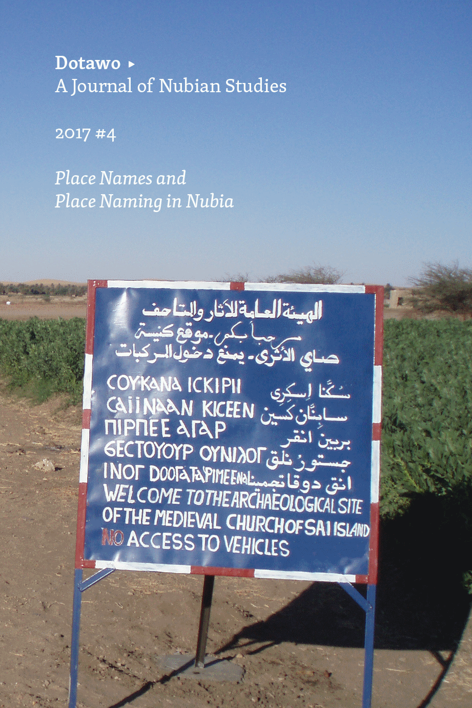
Nubian Gazetteer: KML file downloadSalvoldi, Daniele; Geus, Klaus: A Historical Comparative Gazetteer for Nubia. In: Dotawo: A Journal of Nubian Studies 4 (Summer 2017), 59–182 [ISBN-13: 978-1-947447-20-2; free pdf in open access under https://punctumbooks.com/titles/dotawo-a-journal-of-nubian-studies-4/]. With sixteen colour maps.
Here is the basic .kml file for download. Please share and let's make it standard!
The OldMapsOnline Portal is an easy-to-use gateway to historical maps in libraries around the world.
OmnesViae: Roman Routeplanner: a reconstruction of an antique Roman map with internet technologyOmnesViae.org is an initiative by René Voorburg. It is born out of a fascination for the culture of the ancient Romans. OmnesViae wouldn't have been possible without Richard Talbert's research work on the Tabula Peutingeriana.
Between March and September 2011, I've spent hundreds of hours of scarce spare time creating OmnesViae. Therefor I would like to thank my wife Mariet above all for her patience with my obsessive zeal.
OmnesViae is not just the work of one person. The website http://www.tabula-peutingeriana.de/ by Martin Weber proved to be a useful reference and a handy source for current day place names. The geolocations in OmnesViae are for a large part obtained from the Pleiades initiative. Many people gave me feedback or helped me with translations. I particularly would like to thank Maria Tzaneti, Marlene Sturm, Tim Koster, Martin Weber, Hans de Bode, Ben Mugnier, Eric Rulier, Wouter Kool, Aad Oliehoek and Claude Chauviere.
British Mandate: A Survey of Palestine, prepared by the British Mandate for UN prior to proposing the 1947 partition plan
This is the official books produced by Government of Palestinian (British Mandate) for the years of 1944-1945 which was prepared by the British Mandate for the United Nation Special Committee on Palestine (UNSCOP) in 1946. These three volumes contain a wealth of information about Palestine until the end of 1946...
On-line Geographical Information System for the Theban Necropolis (OLGIS-TN)The Theban Necropolis Geological Mapping Project of the University of Charleston and the Serapis Research Institute announces the creation of the On-line Geographical Information System for the Theban Necropolis (OLGIS-TN), a pilot project sponsored, in part, by the College of Charleston Santee-Cooper Geographic Information Systems Laboratory. It functions as an Internet clearing house to which scholars of the Theban necropolis can retrieve and contribute relevant data related to the cemeteries of ancient Thebes (located on the West Bank of modern Luxor, Egypt).
Orbis Latinus Online (OLO) Lateinisch-Deutsche Ortsnamen
Der Gazetteer Orbis Latinus Online (OLO) für Lateinisch-Deutsche Ortsnamen basiert auf der dreibändigen Druckausgabe von Orbis Latinus aus dem Jahr 1972.
ORBIS: The Stanford Geospatial Network Model of the Roman WorldORBIS: The Stanford Geospatial Network Model of the Roman World reconstructs the time cost and financial expense associated with a wide range of different types of travel in antiquity. The model is based on a simplified version of the giant network of cities, roads, rivers and sea lanes that framed movement across the Roman Empire. It broadly reflects conditions around 200 CE but also covers a few sites and roads created in late antiquity.
The model consists of 751 sites, most of them urban settlements but also including important promontories and mountain passes, and covers close to 10 million square kilometers (~4 million square miles) of terrestrial and maritime space. 268 sites serve as sea ports. The road network encompasses 84,631 kilometers (52,587 miles) of road or desert tracks, complemented by 28,272 kilometers (17,567 miles) of navigable rivers and canals.
PADIS: Palestine Archaeological Databank and Information SystemA tool for protection, study and valorization of the Archaeological Heritage of Palestine
- A coherent organization of archaeological and topographical data from Palestine.
- An interactive databank created to prompt the safeguard of archaeological and historical sites and as scientific and practical tool for the protection, study and cultural valorization.
- A database including satellite images, aerial photos, excavation photos, topographic maps, and updated bibliographic references, expandable with the cooperation of Palestinian scholars and institutions.
Pelagios: Enable Linked Ancient Geodata In Open SystemsPELAGIOS stands for 'Pelagios: Enable Linked Ancient Geodata In Open Systems' - its aim is to help introduce Linked Open Data goodness into online resources that refer to places in the Ancient World. Why do we want to do that? Well, we think it will make all sorts of other things possible, including new modes of discovery and visualization for scholars and the general public. Pelagios also means 'of the sea', the superhighway of the ancient world - a metaphor we consider appropriate for a digital resource that will connect references to ancient places.
PeripleoPeripleo* is a search engine to data maintained by partners of Pelagios Commons, a Digital Humanities initative aiming to foster better linkages between online resources documenting the past.
Peripleo is an initiative by Pelagios Commons, developed under the leadership of the Austrian Institute of Technology, Exeter University, The Open University, the University of London School of Advanced Study and the Alexander von Humboldt Institute for Internet and Society.
Piggin Peutinger DiagramThe most famous map in the world is the Tabula Peutingeriana, a Roman chart of roads and seas. In 2007, UNESCO placed it on its Memory of the World Register, a global list of 301 documents (as of 2013) which are irreplaceable to comprehend our recent and distant past.
PleiadesSpringing from the Classical Atlas Project and the Barrington Atlas of the Greek and Roman World, Pleiades is a historical gazetteer and more. It associates names and locations in time and provides structured information about the quality and provenance of these entities. There is also a graph in Pleiades: names and locations are collected within places and these collections are associated with other geographically connected places. Pleiades also serves as a vocabulary for talking about the geography of the ancient world within Linked Data sets and is referenced by research projects such as Google Ancient Places and PELAGIOS.
Pompeii Bibliography and Mapping ProjectThe Pompeii Bibliography and Mapping Project is working to create a unique resource that binds two resources in a responsive online user interface. The first component is an exhaustive database of citations and full-text repository relating to the ancient city of Pompeii. The second component is a Geographical Information System (GIS) map of that ancient city. Both of these components are available in their beta formats. The online interface planned will allow a user to navigate the bibliographic database and repository via the GIS map or, conversely, to illustrate places in the GIS map found in a search of the database or repository. These components are described in greater detail in the following sections.
POTSHERD : Atlas of Roman Pottery
This is a collection of pages on pottery and ceramics in archaeology, principally of the Roman period (1st cent. BC - 5th cent. AD) in Britain and western Europe.
- The pages include an introductory Atlas of Roman Pottery, containing descriptions and distribution maps of types of Roman pottery (particularly types found in Britain).
- The pages of the Atlas describing the individual wares can be accessed through the main menu, which lists the wares by CLASS (table wares, cooking wares, transport amphoras etc) or SOURCE (by province of origin). Links to these indices will also be found in the main menu bar.
Proxeny Networks of the Ancient World (a database of proxeny networks of the Greek city-states)
About
PNAW is a database of evidence for a particular kind of social networking between Greek city-states in the Ancient Greek world, known as proxeny (Greek: proxenia). It enables this material to be used to visualise the highly-fragmented political geography of the ancient world during the Archaic, Classical, and Hellenistic periods, and to get a sense of how densely and intensely interconnected were the states which made it up.
QuarryScapes AtlasThe QuarryScapes Atlas displays a variety of ancient quarry landscapes. The purpose of the atlas is first of all to show the great variability of such landscapes and introducing them with photos and few words. The atlas will be further developed, and hopefully evolve to a comprehensive web-book with contributions from many researchers. In this first edition of the atlas we have picked 15 quarry landscapes; most of them in the project region, but also a few outside. Collectively, these 15 sites display a broad range of quarry landscapes; different periods and historical settings, different geology, morphology and climate. Also, they are in different stages of development as cultural heritage sites, from “unknown and remote” to outdoor museums.
Recogito: Linked Data annotation without the pointy bracketsRecogito is an initative by Pelagios Commons, developed under the leadership of the Austrian Institute of Technology, Lancaster University and The Open University, with funding from the Andrew W. Mellon Foundation.
Recogito is provided as Open Source software, under the terms of the Apache 2 license. It can be downloaded free of charge for self-hosting from our GitHub repository.
Pelagios Commons offers free access to a hosted version of the software at recogito.pelagios.org in the spirit of open data and as an act of collegiality. Please refer to our Terms and Conditions of Use for information.
Register of Ancient Geographic Entities (RAGE)A cooperative effort to provide the infrastructure for cross-project placname searches and interactive online mapping applications.
Regnum Francorum Online — interactive maps and sources of early medieval Europe 614-840This is a website about visualizing early medieval Europe 614-840 on maps. Here you will find interactive maps of the Frankish kingdom, activities of Merovingian and Carolingian kings, donations of the nobility and development of the property of monasteries and other institutions. The locations on the map are clickable and connected to quotes from, and references to primary sources and literature. Simply click on a location and discover which sources are available on this site and on the internet for a particular city. There is an overview of the interactive maps in the Gallery section, intended as a starting point if you are new to this website.
Resources for Teaching Ancient GeographyFrom History From Below: Musings on Daily Life in the Ancient and Early Medieval Mediterranean By Sarah E. Bond
Roman Roads and Milestones in Judaea/PalaestinaIn 1970 The Israel Milestone Committee (IMC) was formed by Mordechai Gichon as a branch of the International Curatorium of the Corpus Miliariorum. The aim of the committee was to assemble, study and prepare for publication the milestones inscriptions found in Israel. The IMC also intended to carry out a systematic survey of all the extant remains related to roads, in order to provide a comprehensive picture of the Roman road network in Israel. For almost 40 years the Committee's field and research work was led by Israel Roll and Benjamin Isaac together with other scholars.
The Romans: From Village to Empire: A History of Rome from Earliest Times to the End of the Western Empire (2nd edition; 2011)A second edition of Mary T. Boatwright, Daniel J. Gargola, Noel Lenski, Richard J. A. Talbert The Romans: From Village to Empire: A History of Rome from Earliest Times to the End of the Western Empire has appeared from Oxford University Press (2011). The following list provides access to digital (.pdf) versions of the maps that appear in the text. As the files are large, we recommend that you right click the link below the thumbnail and save a local copy..
ROMAQ: The Atlas Project of Roman AqueductsRoman aqueducts are amongst the most impressive and interesting structures that have survived from the Ancient World. Although aqueduct bridges such as the Pont du Gard are best known, roman aqueducts are complex water supply line systems that are impressive feats of engineering even by today's standards. Some of the aqueducts are simple water channels, but many contain complex structures such as inverted siphons, tunnels, basins and drop shafts while the channels themselves can be up to 240 km in length. Over 1400 roman aqueducts have been described in the Mediterranean basin and the aim of this website is to present the available corpus of literature on the subject in a systematic way. Besides available literature on each aqueduct, we aim to present summarised data on each aqueduct. However, this is a project in development, and it will take time to add new data and publications, and to update content.
Rome’s World: The Peutinger Map ReconsideredThe Peutinger Map is the only map of the Roman world to come down to us from antiquity. An elongated object full of colorful detail and featuring land routes across Europe, North Africa, and the Near East, it was mysteriously rediscovered around 1500 and then came into the ownership of Konrad Peutinger, for whom it is named. Today it is among the treasures of the Austrian National Library in Vienna. Richard J. A. Talbert’s Rome’s World: The Peutinger Map Reconsidered offers a long overdue reinterpretation and appreciation of the map as a masterpiece of both mapmaking and imperial Roman ideology...
Stanford Digital Forma Urbis Romae ProjectThis site is dedicated to exploring the Forma Urbis Romae, or Severan Marble Plan of Rome. This enormous map, measuring ca. 18.10 x 13 meters (ca. 60 x 43 feet), was carved between 203-211 CE and covered an entire wall inside the Templum Pacis in Rome. It depicted the groundplan of every architectural feature in the ancient city, from large public monuments to small shops, rooms, and even staircases. For more information about the map itself, go to the Map page.
The Syriac GazetteerEditors: Thomas A. Carlson (Princeton University) and David A. Michelson (Vanderbilt University)
The Syriac Gazetteer is a geographical reference work of Syriaca.org for places relevant to Syriac studies. It is growing from an initial publication of over two thousand place records.
TerraWatchers: Crowd Sourced Satellite Image AnalysisTerraWatchers is dedicated to providing web-based, crowdsourced satellite image monitoring and overwatch tools for critical missions related to current events. We use interactive Google Maps© interfaces to display the latest freely available, high-resolution satellite imagery in our mission footprints.
Theban Mapping Project Since its inception in 1978, the Theban Mapping Project (TMP, now based at the American University in Cairo) has been working to prepare a comprehensive archaeological database of Thebes. With its thousands of tombs and temples, Thebes is one of the world's most important archaeological zones. Sadly, however, it has not fared well over the years. Treasure-hunters and curio-seekers plundered it in the past; pollution, rising ground water, and mass-tourism threaten it in the present. Even early archaeologists destroyed valuable information in their search for museum-quality pieces.
Today, however, we realize that the monuments of Thebes are a finite resource. If we fail to protect and monitor them, they will vanish, and we and our descendants will all be the poorer. The TMP believes that the first and most essential step in preserving this heritage is a detailed map and database of every archaeological, geological, and ethnographic feature in Thebes. Only when these are available can sensible plans be made for tourism, conservation, and further study.
During the last decade, the TMP has concentrated on the Valley of the Kings. Modern surveying techniques were used to measure its tombs. From the data collected, the TMP is preparing 3-D computer models of the tombs. And of course, the TMP is continuing its excavation of KV 5. For the TMP staff, sharing their work with the interested public is just as important as what they do in the field. This has been done through a series of publications and this growing website.
Theban Tombs Satellite Mapping ProjectWelcome to the Theban Tombs Satellite Mapping Project! The map is designed to be an interactive experience for users. You will be able to zoom in and out, view information about buildings and parking lots, and print out findings. This menu is to help you to understand the functions of the map in order to provide a more fulfilling experience!
al-Ṯurayyā ProjectThis is a new working version of the al-Ṯurayyā project which currently includes the gazetteer (al-Ṯurayyā Gazetteer, or al-Thurayyā Gazetteer), and the geospatial model of the early Islamic world. Both parts of the project are still under development.
TOPOSTextTOPOSText 2.0
ToposText is an indexed collection of ancient texts and mapped places relevant the the history and mythology of the ancient Greeks from the Neolithic period up through the 2nd century CE. It was inspired by two decades of exploring Greece by car, foot, or bicycle, and by clumsy efforts to appreciate επί τόπου the relevant information from Pausanias or other primary sources. The development of mobile electronic devices since 2010 has coincided with an increasingly comprehensive assortment of ancient texts available on the internet. The digital texts I collected on an e-reader in 2012 made clear both the pleasure of having a portable Classics library but also the desperate need to organize the information it contained. Discovering the Pleiades Project, with its downloadable database of thousands of ancient place names and coordinates, opened the door to indexing ancient texts geographically, using a map of Greece as the basic interface.
Traveling with Pausanias: Using Google Earth to Engage Students with Ancient MapsJohn Gruber-Miller December 14th, 2012 There are several files available: Rivers of Pausanias Book 5 (including the rivers of Arcadia, and the Jordan River), Cataracts of the Nile, and Olympic winners named in Pausanias 5.8-9 and their hometowns. To download the .KMZ files (in a compressed/ZIP folder), please click here.
Trismegistos Places (GEO and GEOREFCurrently 30495 place records (GEO) and 117663 place attestation records (GEOREF).
A database of places related to the ancient world
by Trismegistos
Based on the foundations of the Fayum Project (Graeco-Roman Egypt) of the KULeuven and the project Multilingualism and Multiculturalism in Graeco-Roman Egypt of Cologne University.
Unlocking historic landscapes in the eastern Mediterranean
Jim Crow (University of Edinburgh) and Sam Turner (Newcastle University), 2010In many areas of the Eastern Mediterranean there are landscapes exhibiting exceptional time-depth, where the historic landscape is made up of visible features from many different periods. Our research adapted and used a new technique developed in Britain (Historic Landscape Characterisation - HLC) for the first time in the eastern Mediterranean to study these landscapes. HLC is a method for mapping the landscape that can be used to interpret how and when different elements were created. Using Geographical Information Systems (GIS) we integrated data from historical, archaeological and other sources to create detailed, long-term landscape histories of two case-studies areas.
Vías Romanas en Castilla y LeónEn este trabajo se presentan los resultados de una labor de investigación llevada a cabo entre los años 2007 a 2010, circunscrita a la Comunidad de Castilla y León. Muchas de las identificaciones proceden de labores que el autor llevaba realizando bastantes años antes sobre la caminería antigua en general y sobre la romana en particular. Se han conseguido identificar unos 2400 kilómetros de caminos romanos ciertos, cuyos vestigios estructurales, constructivos, toponímicos y epigráficos, en este orden y en razón al valor de cada uno de estos factores, nos han determinado su existencia. Vías Romanas en Castilla y León.
Vici.org: Archaeological Atlas of AntiquityVici.org is the archaeological atlas of classical antiquity. It is a community driven archaeological map, inspired by and modelled after Wikipedia.
The first version of Vici.org went online in May 2012. It was preceded by a sister website Omnesviae.org, a roman routeplanner based on the Peutinger map. Since its start, Vici.org has grown a lot. At the time to this writing, over 140 contributors have added nearly 20,000 locations, approximately 1,000 line tracings and over 3,000 images.
Views of Rome: Anteiquae Urbis ImagoViews of Rome is the online home of the 1773 edition of Pirro Ligorio’s Anteiquae Urbis Imago (Image of the Ancient City) held at Emory University. Originally published in 1561, the Imago is a cartographic reconstruction of fourth-century AD Rome. A high-resolution scan of the map exists as an interactive digital tool for use by students in the classroom and by members of the general public.
Virtual Cilicia ProjectSurrounded by the steep Taurus and Amanus mountain ranges, the fertile alluvial plain of Cilicia Pedias in modern Turkeyis a true treasury of important monuments from numerous ages. Hittite and Assyrian rock reliefs serve as representations of power at this connection between Anatoliaand the Levant. Since it relies on Goggle Earth, the Virtual Cilicia Project is able to show you these monuments as well as the ruins of Bronze and Iron Age settlements like e.g. Karatepe with its world-famous carved orthostats in their natural environments.
The West Bank and East Jerusalem Searchable MapThis collection includes lists of archaeological sites that have been surveyed or excavated since Israel occupied the West Bank and East Jerusalem in 1967. Since that time, the oversight of the antiquities of the area has devolved on two government bodies: the military administration's Staff Officer for Archaeology (SOA) in Judea and Samaria and the Israel Antiquities Authority (IAA). The IAA, which is responsible for East Jerusalem, is a civil branch of government and its records are open for inspection. Some of the records of the Staff Officer for Archaeology in Judea and Samaria are being accessed in full for the first time as a result of the joint Israeli-Palestinian Archaeology Working Group. This involved a team of Israeli and a team of Palestinian archaeologists and cultural heritage professionals working in concert to create new data resources that document the single, unitary archaeological landscape of the southern Levant, which is now bisected by the modern borders.
Women of ASOR MapThe “Women of ASOR” Map will act as a networking resource for ASOR’s membership, as it displays the locations of professional female members around the globe – pinpointing the universities, museums or other organizations where they work and the sites at which they excavate...
World Atlas of Language Structures (WALS)The World Atlas of Language Structures (WALS) is a large database of structural (phonological, grammatical, lexical) properties of languages gathered from descriptive materials (such as reference grammars) by a team of 55 authors (many of them the leading authorities on the subject).